1. Where is Ha Tinh Province on the Vietnam map?
Ha Tinh is a province located in the central region of Vietnam, specifically the North Central Coast. It borders Nghe An Province to the north, Quang Binh Province (now Quang Tri Province) to the south, Laos to the west, and the East Sea to the east, boasting a coastline stretching 137 kilometers. Ha Tinh lies about 350 kilometers away from Hanoi and roughly 1,330 kilometers away from Ho Chi Minh City.
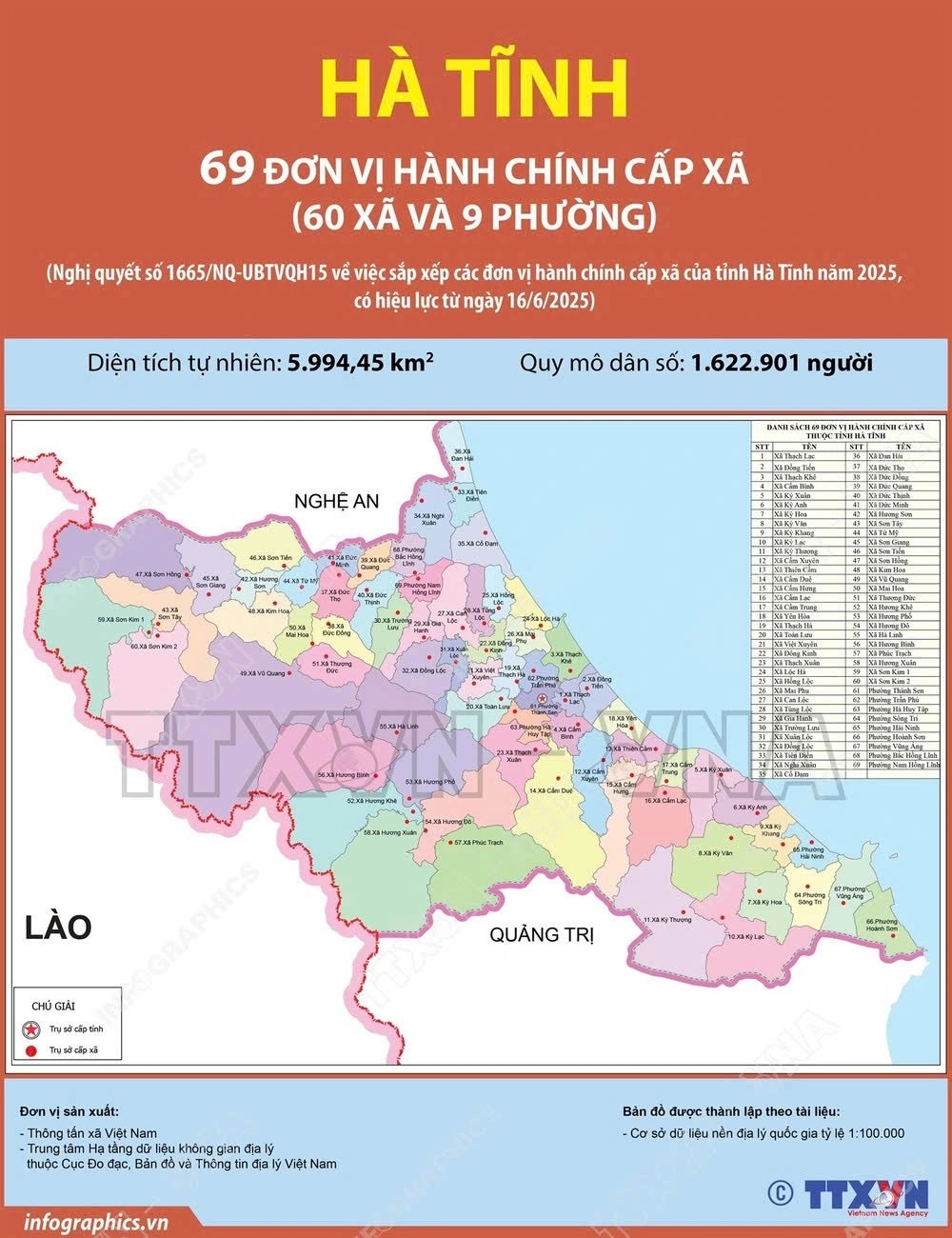
2. Administrative map of Ha Tinh Province
After the recent administrative rearrangement, Ha Tinh Province now consists of 69 commune-level units, including 60 communes and 9 wards.
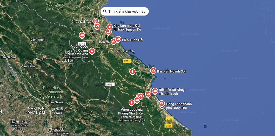
3. Unmissable attractions on the Ha Tinh tourist map
Ha Tinh is a land rich in history, culture, and nature. Stretching nearly 137 kilometers along the coast, Ha Tinh boasts numerous pristine beaches, tranquil lakes, dense national parks, and sacred relics, offering tourists diverse experiences that combine relaxation and exploration.
3.1. Thien Cam Beach
- Location: Thien Cam Commune
Considered one of the most beautiful beaches on the Ha Tinh Vietnam map, Thien Cam Beach attracts a large number of visitors every year. Nestled between Thien Cam Mountain and Dau Voi Mountain, it stretches nearly 3 kilometers in a graceful crescent shape, earning it the nickname “the musical bow of the Central Coast”. Here, tourists can freely swim in the clear water, take peaceful walks along the emerald-blue shore, listen to the gentle waves crashing against the rocky cliffs, admire the picturesque scenery, and savor a variety of unique dishes made from fresh seafood.
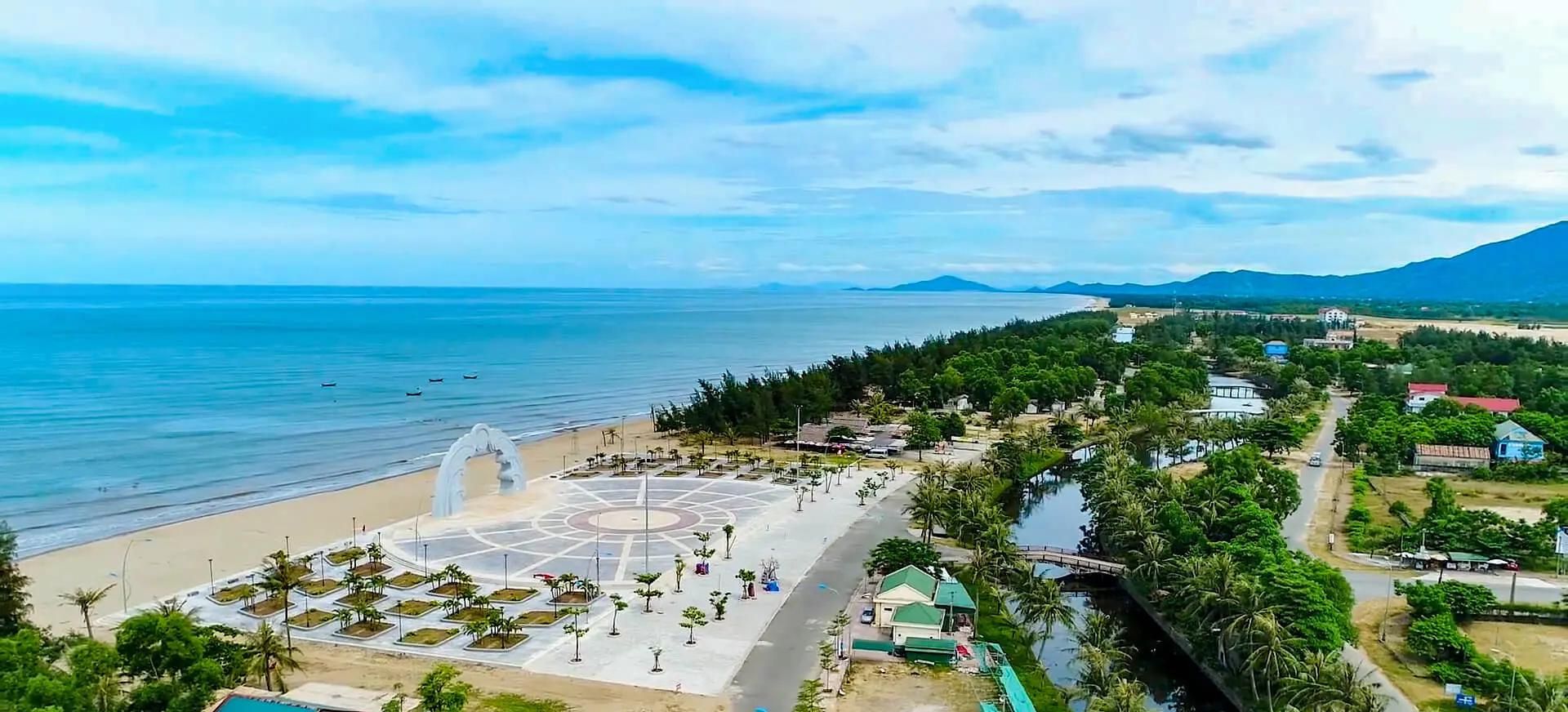
3.2. Xuan Thanh Beach
- Location: Tien Dien Commune
Xuan Thanh Beach is a peaceful alternative to the busier Thien Cam Beach. Here, tourists can swim, feast on fresh seafood, join beach activities, and watch thrilling dog races or horse shows. The area also features a lively night food street, a square, outdoor stages, and family-friendly entertainment.
In addition to Xuan Thanh and Thien Cam, the Ha Tinh Vietnam map also highlights several other beautiful beaches worth exploring such as Thach Hai, Ky Ninh, Ky Xuan, Xuan Hai, and Hoanh Son. They offer a mix of pristine sands, clear waters, and tranquil surroundings, perfect for swimming and sunbathing.
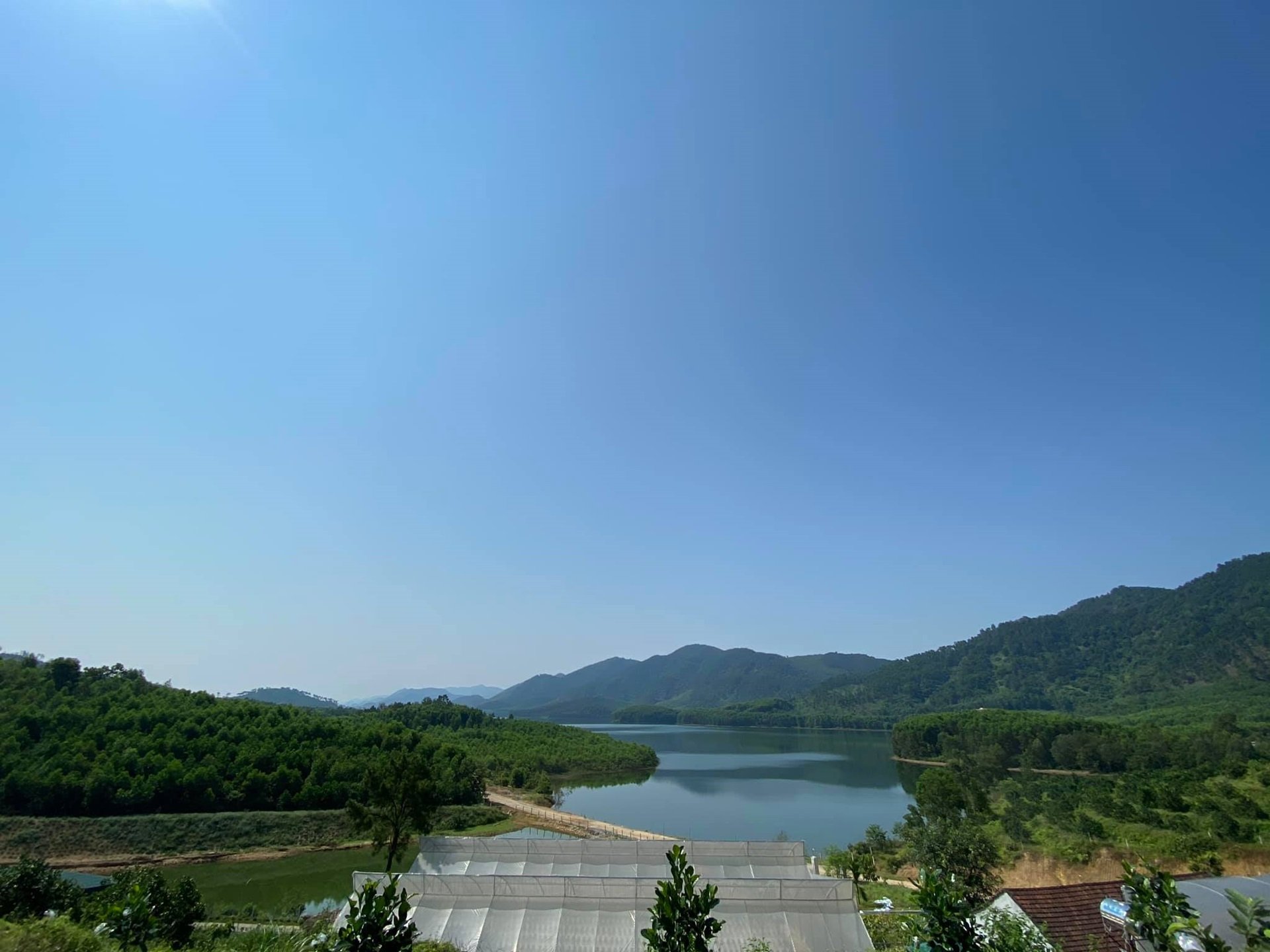
3.3. Ke Go Lake
- Location: Cam Due Commune
Ke Go Lake, part of Ke Go Nature Reserve, is the largest man-made freshwater lake on the Ha Tinh Vietnam map. Built between 1976 and 1979, this lake is not only a vital irrigation source but also a scenic spot for sightseeing. A distinctive C-shaped bridge crosses the lake, leading to the memorial temple of Le Duan, adding historical significance to the site. Today, Ke Go Lake is a favorite weekend destination for camping, picnics, and family gatherings. Tourists can enjoy the tranquil atmosphere, take in the surrounding mountain views, or explore the diverse flora and fauna of the nature reserve.
3.4. Trai Tieu Lake
- Location: Dong Loc Commune
Marked as a hidden gem on the Ha Tinh Vietnam map, Trai Tieu Lake spans 21 square kilometers and holds up to 15.6 million cubic meters of water. While serving as a vital reservoir, it also offers a serene escape for nature lovers. Tourists can climb the breezy pine-covered hills while listening to the rustling trees, or cruise on the lake to explore its vast expanse. Upstream, you can visit war relics or stop by thriving fruit farms for seasonal specialties. Guests can also savor local dishes such as braised loach, salt-roasted Ri chicken, eel, and native pork, making the visit a full sensory experience of Ha Tinh’s charm.
3.5. Vu Quang National Park
- Location: Vu Quang Commune
Vu Quang National Park, located near the Vietnam - Laos border, is a standout attraction on the Ha Tinh map. Covering over 55,000 hectares, it is home to thousands of plant and animal species, including many rare and endangered ones. Within the park lies Ngan Troi Dam, which plays a vital role in supporting local communities and the whole province. Vu Quang National Park also offers a nature-friendly escape with a variety of activities. Tourists can explore scenic lakes, enjoy swimming under waterfalls, go boating, or spend the night camping surrounded by lush forests.
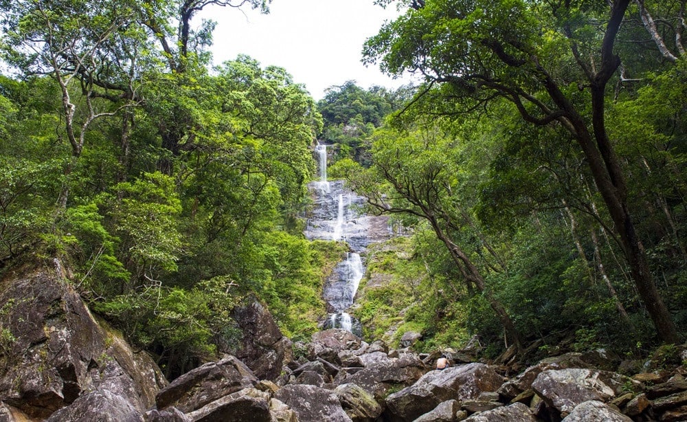
3.6. Vu Mon Waterfall
- Location: Huong Khe Commune
Perched 1,300 meters above sea level, Vu Mon Waterfall is a stunning four-tiered cascade, with a year-round flow fed by Giang Man Mountain. This site is steeped in legend: each year on the 8th day of the 4th lunar month, carp are said to leap over the falls, signaling luck and bountiful harvest. Tourists can admire its untouched beauty, breathe in the serene mountain air, immerse themselves in the cool water, or take photos on the large flat rocks at the base. With breathtaking scenery and rich folklore, Vu Mon Waterfall is an unmissable spot on the Ha Tinh Vietnam map.
3.7. Ngang Pass
- Location: Hoanh Son Commune
Ngang Pass is located along National Road 1A on the Ha Tinh Vietnam map, at the border of Ha Tinh and Quang Tri provinces. Rising over 250 meters above sea level and stretching approximately 6 kilometers, it offers breathtaking views of the surrounding mountains and valleys. Tourists can hike along the pass to fully appreciate its natural beauty, or for a quicker journey, take the road tunnel that cuts through the mountains. At the summit, you will find Hoanh Son Quan, an ancient gateway built during King Minh Mang’s reign (1833), often called the “Heaven’s Gate.”
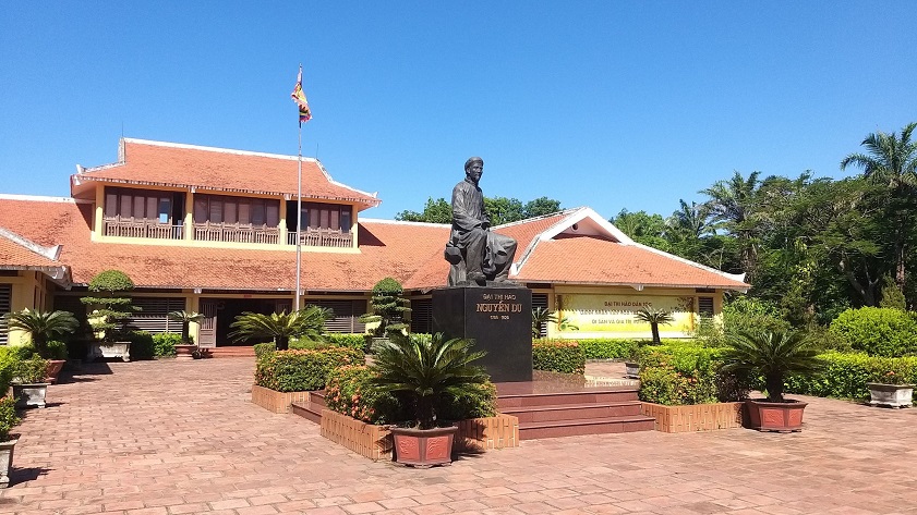
3.8. Nguyen Du Relic Site
- Location: Tien Dien Commune
Nguyen Du Relic Site honors Vietnam’s celebrated poet Nguyen Du, author of the renowned “The Tale of Kieu.” This memorial draws scholars, writers, and visitors from across the country and abroad to pay homage at his tomb and explore the Nguyen family heritage complex. The site features a museum showcasing Nguyen Du’s life and career, the poet’s ancestral house, and several temples and shrines. Here, tourists can immerse themselves in rich cultural and historical significance, learning about Vietnam’s literary legacy while enjoying the peaceful atmosphere of Tien Dien Village.
3.9. Dong Loc T-junction Relic Site
- Location: Dong Loc Commune
Dong Loc T-junction, a historical site on the Ha Tinh Vietnam map, is located along the Ho Chi Minh Trail through the Truong Son Mountain Range. During the war, it was a key transport point, which American forces frequently targeted with bombings to cut off the movement of Vietnamese troops. At that time, a squad of female volunteers was assigned to guard the junction, disarm unexploded bombs, and repair roads. Their lives were lost on July 24, 1968, when a bomb fell right near the shelter where they were taking cover. Today, visitors can pay tribute to these heroic young women at the memorial, explore historical markers, and see bomb craters.
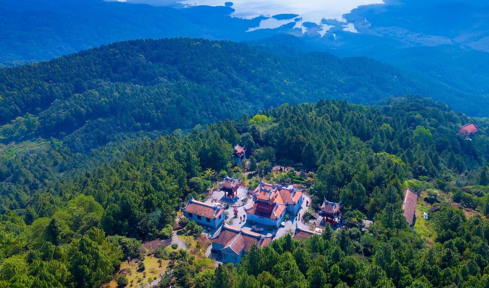
3.10. Huong Tich Pagoda
- Location: Can Loc Commune
Huong Tich Pagoda sits on the slopes of Hong Linh Mountain on the Ha Tinh Vietnam map. Here, tourists can explore the mountain, wander through lush forests, take in breathtaking scenery, and learn the story of Princess Dieu Thien, who transformed into a Bodhisattva to save the people. The pagoda is also the center of the annual Huong Tich Festival, which is held from the 6th day of the 1st lunar month, with the main ceremony taking place on the 18th day of the 2nd lunar month. During this time, thousands of pilgrims gather at Huong Tich Pagoda to light incense and pray for prosperity.
Exploring the Ha Tinh Vietnam map reveals a land full of hidden gems, from pristine beaches and peaceful lakes to historical relics and national parks. Each attraction offers its own charm, blending natural beauty with cultural depth. Whether you are planning a short getaway or a longer journey, the Ha Tinh Vietnam map is a perfect guide to unforgettable experiences in this coastal province.
To make the most of your trip in Ha Tinh, stay at Vinpearl Ha Tinh, Affiliated by Meliá or Vinpearl Cua Sot Resort, Affiliated by Meliá. Both offer modern amenities, elegant rooms, swimming pools, fine dining, gyms, and convenient access to local attractions - making them perfect retreats to relax after a day of discovery in Ha Tinh.

Book rooms in Vinpearl Ha Tinh, Affiliated by Meliá

Book rooms in Vinpearl Cua Sot Resort, Affiliated by Meliá